
Interactive Maps
PLANNING COORDINATION COMMITTEE MAPPER
SENSITIVE LANDS PROTECTION PLAN MAPPER
1. The Gallatin County interactive mappers are a great place to start when it comes to your property-related questions and projects. In addition to the two mappers referenced above, the County GIS Office maintains additional mappers that can be accessed here. The below instructions are specific to the Zoning and Floodplain Mapper.
2. To navigate to a specific property within the county, use the search feature in the upper left corner. Click on the magnifying glass to access the search bar. Use the drop down menu to search by address, road, or other identifying information. Note: this map is only for Gallatin County
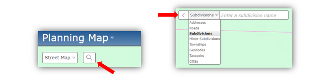
You can also click and drag on the map if you prefer to navigate the map that way.
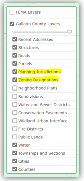
3. Notice on the right the list of available layers that may be of interest to you. If you are interested in zoning and permitting for a parcel of land, the two most important layers to turn on will be the “Planning Jurisdictions” and the “Zoning Designation” layers.
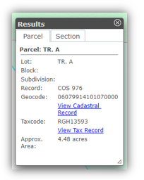
4. Once these two layers are turned on and you have found your parcel, you are ready to determine the zoning regulations! If you click on the parcel a pop-up should appear with the appropriate information.
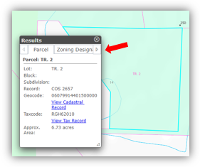
You can use the arrows and click through the tabs on the pop-up for the specific information you are interested in. For most projects you will want to know the planning jurisdiction, zoning district, and the zoning designation. Note: If you have the planning jurisdiction layer turned on, but a tab for it does not appear in the pop-up, you are within the Gallatin County jurisdiction by default.
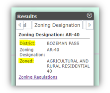
In the above example, the Zoning District is “Bozeman Pass” and the designation is “Agricultural and Rural Residential 40”. The shorthand for the zoning designation is “AR-40”.
5. After you have determined the Zoning District and the designation, you are ready to read the regulations applicable to the parcel of land. You can either go directly to the list of zoning regulations or use our zoning guide to proceed with additional guidance.
Other helpful information:
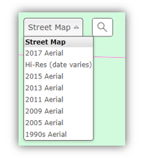
- You can change your base map using the drop down menu in the upper left corner.
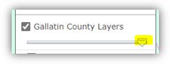
- The transparency of the layers can be adjusted by using this slider in the layer menu on the right. To increase transparency, click the adjuster and slide to the left.
- If the property in question is listed as being in a specific planning jurisdiction (Belgrade, Manhattan, etc) then you will need to contact that office directly for further information. The office numbers are listed below:
- City of Bozeman: 406-582-2260
- City of Belgrade: 406-388-3783
- Town of Manhattan: 406-284-3235
- Town of Three Forks: 406-285-3431
- Town of West Yellowstone: 406-646-7795
- If the property in question does not have a zone listed, and the zoning designation layer is turned on, then the parcel is considered unzoned. Unzoned properties do not require permits through the county planning office unless you are in the floodplain or intending to subdivide or rent/lease out units.
The best practice in this situation is to:
1. Verify with the Gallatin County Planning Department that the property is indeed unzoned, and
2. Check with any applicable covenants or HOAs that may be related to the property.
Also, keep in mind that if your project requires sewer/septic you will still require permits through the Gallatin Environmental Health Department. Some projects may also require additional permitting from the local Fire District, and/or through the Montana State Building Codes office.